After more than a decade of development, NASA's science leadership traveled to India this week for the launch of the world's most expensive Earth-observation satellite.
The $1.5 billion synthetic aperture radar imaging satellite, a joint project between NASA and the Indian space agency ISRO, successfully launched into orbit on Wednesday aboard that nation's Geosynchronous Satellite Launch Vehicle, a medium-lift rocket.
The mission, named NISAR (NASA-ISRO Synthetic Aperture Radar), was subsequently deployed into its intended orbit 464 miles (747 km) above the Earth's surface. From this Sun-synchronous orbit, it will collect data about the planet's land and ice surfaces two times every 12 days, including the infrequently visited polar regions in the Southern Hemisphere.
Two for one
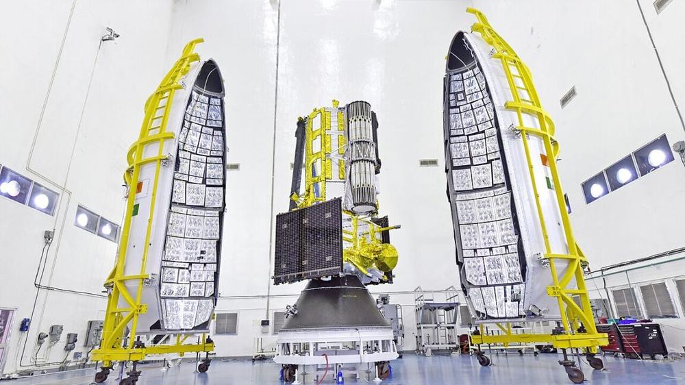
The satellite combines two main instruments that, unlike optical telescopes, can gather data through clouds and at night. NASA provided the L-band synthetic aperture radar, which is efficient at measuring soil moisture, forests, and the movement of land and ice on the surface of the planet. India contributed an S-band radar that is useful for measuring agricultural changes, as well as grasslands and human-built structures.
NASA and other spaceflight organizations have been developing and flying synthetic aperture radar for decades, but the NISAR spacecraft is one of the first missions to combine two different bands onto a single vehicle. This should provide a more comprehensive view of how the planet's surface is changing on a real-time basis.
After Wednesday's launch, the spacecraft will undergo a three-month commissioning phase. During this time NISAR will deploy a very large antenna reflector that is 39 feet (12 meters) in diameter. This reflector will send and receive microwaves from the two radars and use differences to measure the surface below.
Notable for cost and collaboration
The NISAR mission is notable both for its price tag—Earth observation missions typically cost less because they do not need to be hardened for long-duration flight in deep space—as well as the partnership with India. In terms of complexity and cost, this is the largest collaboration between NASA and ISRO to date and could set a template for further cooperation in space as part of the Artemis program or other initiatives.
"The powerful capability of this radar mission will help us study Earth’s dynamic land and ice surfaces in greater detail than ever before," said V. Narayanan, chair of the Indian space agency, in a statement after the launch. "With this successful launch, we are at the threshold of fulfilling the immense scientific potential NASA and ISRO envisioned for the NISAR mission more than 10 years ago."
As Narayanan noted, the development of the NISAR mission has spanned more than a decade. The US and Indian space agencies signed the partnership agreement on September 30, 2014, to design and build the spacecraft. At the time, launch was targeted for 2024, so missing that deadline by less than a year is quite respectable.
Who deserves credit?
After the launch, NASA Acting Administrator Sean Duffy, on social media site X, celebrated the successful deployment of the spacecraft. However, Duffy did not quite have his history correct in attributing the mission's success to President Donald Trump.
"The mission is a joint U.S.-India effort, negotiated by President TRUMP," Duffy wrote. "Thanks to his LEADERSHIP & our friends at @ISRO, @NASA is Making Space Great Again!"
Trump did not begin his first term as US President until nearly two and a half years after the partnership between NASA and ISRO was negotiated.
Nevertheless it is likely welcome to NASA's Earth Science program that a Trump appointee acknowledged that a mission designed to study Earth's surface, including the influence of climate change, is of value to the space agency.
Given the Trump administration's proposed cuts to NASA's science programs, it is not clear whether a mission like NISAR could get funded today.
 PlayStation Plus, svelati i giochi gratis di agosto per PS5 e PS4: c'è Lies of P