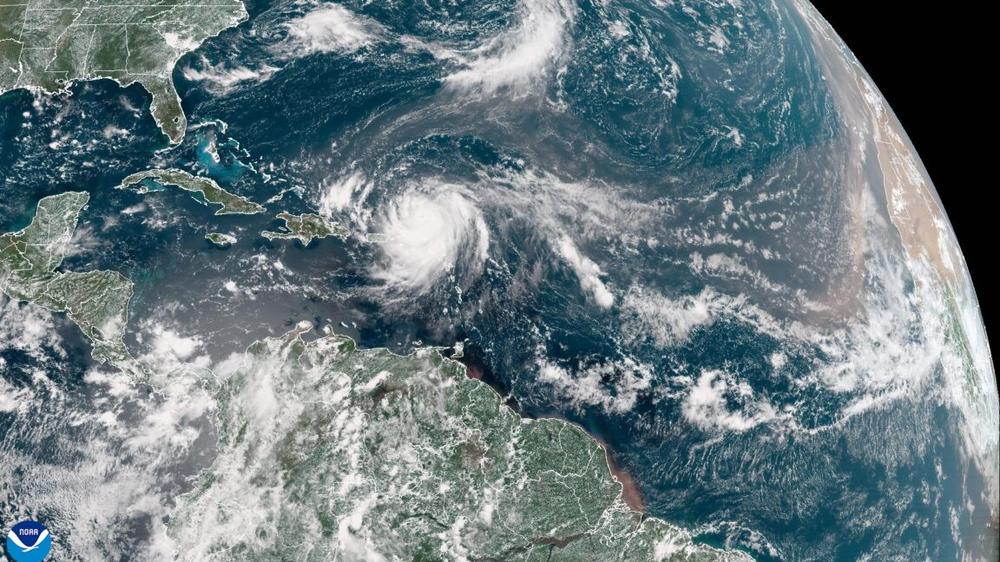
After several days of working its way across the open and at times hostile Atlantic Ocean this week, Hurricane Erin found more favorable conditions and exploded in intensity on Friday night. Shortly before noon on Saturday, the National Hurricane Center declared that Erin had reached Category 5 status, the most powerful kind of hurricane.
This determination is based on sustained winds, which were measured by a US Air Force Hurricane Hunter aircraft on Saturday at 160 mph.
There is some good news: Erin is threading a needle with its projected track. Although it should pass close to several landmasses between now and next Thursday, Erin should remain far enough away to avoid catastrophic damage. Erin is presently passing to the north of the Caribbean islands, and will turn northward before reaching the Bahamas and the Eastern United States. Later next week it should follow a path that takes it between Atlantic Canada and Bermuda.
Forecasters have a reasonable amount of confidence in this track as trusted models have become fairly consistent in their output.
Getting big, fast
There is a sobering side to all of this as well. Erin only became a hurricane at 11 am ET on Friday, as it tracked north of the Leeward Islands. It was the first hurricane of the Atlantic season, which has been relatively slow to rumble to life this year.
However, Erin's growth since then has been historic. Although the Category of a hurricane is based on its sustained winds, a more accurate measurement of a storm's intensity is its central pressure, measured in millibars. The standard pressure at the surface of the Earth is 1,013.25 mb. As they intensify, the central pressure of hurricanes drops, and the lower the pressure the more intense the storm.
According to meteorologist Sam Lillo, Erin deepened by 70 millibars in 24 hours from Friday morning to Saturday morning. This makes Erin the most rapidly intensifying hurricane, before Sept. 1, ever measured in the Atlantic Ocean.
Erin's central pressure was in the 990s this time yesterday, and it's now in the 920's heading for the teens.
This will make Erin the fastest deepening Atlantic hurricane before Sept 1st. Beating Emily 2005, by a lot.
— Sam Lillo (@samlillo.bsky.social) August 16, 2025 at 9:29 AM
With a central pressure of 917 mb on Saturday, Erin ranks as the second-most intense Atlantic in the last 50 years prior to today's date, behind only Hurricane Allen in 1980.
Rapid intensification becoming more common
Storms like Erin are predicted to become more common due to climate change, scientists say. One study in 2019 found that, for the strongest 5 percent of Atlantic hurricanes, 24-hour intensification rates increased by about 3–4 mph per decade from 1982 to 2009. "Our results suggest a detectable increase of Atlantic intensification rates with a positive contribution from anthropogenic forcing," the authors of the study, in Nature Communications, wrote.
Hurricane scientists generally agree that although the overall number of tropical storms and hurricanes may not increase in a warmer world, such background conditions are likely to produce more intense storms like Erin.
According to the US government's Climate.gov website, this increase in intensity of tropical cyclones (TCs) is happening due to human-caused climate change.
"The proportion of severe TCs (Category 4 & 5) has increased, possibly due to anthropogenic climate change," a coalition of authors wrote. "This proportion of intense TCs is projected to increase further, bringing a greater proportion of storms having more damaging wind speeds, higher storm surges, and more extreme rainfall rates. Most climate model studies project a corresponding reduction in the proportion of low-intensity cyclones, so the total number of TCs each year is projected to decrease or remain approximately the same."
To date this year the tropical Atlantic has seen lower overall activity than usual. But with Erin's longevity and intensity this season should soon reach and surpass normal levels of Accumulated Cyclone Energy, a measurement of a season's total activity. The Atlantic season typically peaks in early September, with the majority of storms forming between early August and early October.
Forecast models indicate the likely development of more hurricanes within the next two weeks, but there is no clear consensus on whether they will impact land.
 Putin offers Trump frozen battle lines, written promise not to invade again if Kyiv surrenders Donbas, NYT reports